
This section contains the main land, town-planning and engineering documents of the GREENBOR residential community.
They show how the project territory was formed: from the original land massifs and the Detailed Plan of the Territory to the individual plots for 20 households, the internal road and the shared infrastructure.
A prospective buyer can review the general documents before selecting a particular home and, before completing the transaction, can check the full set of documents for the chosen property.
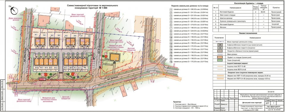
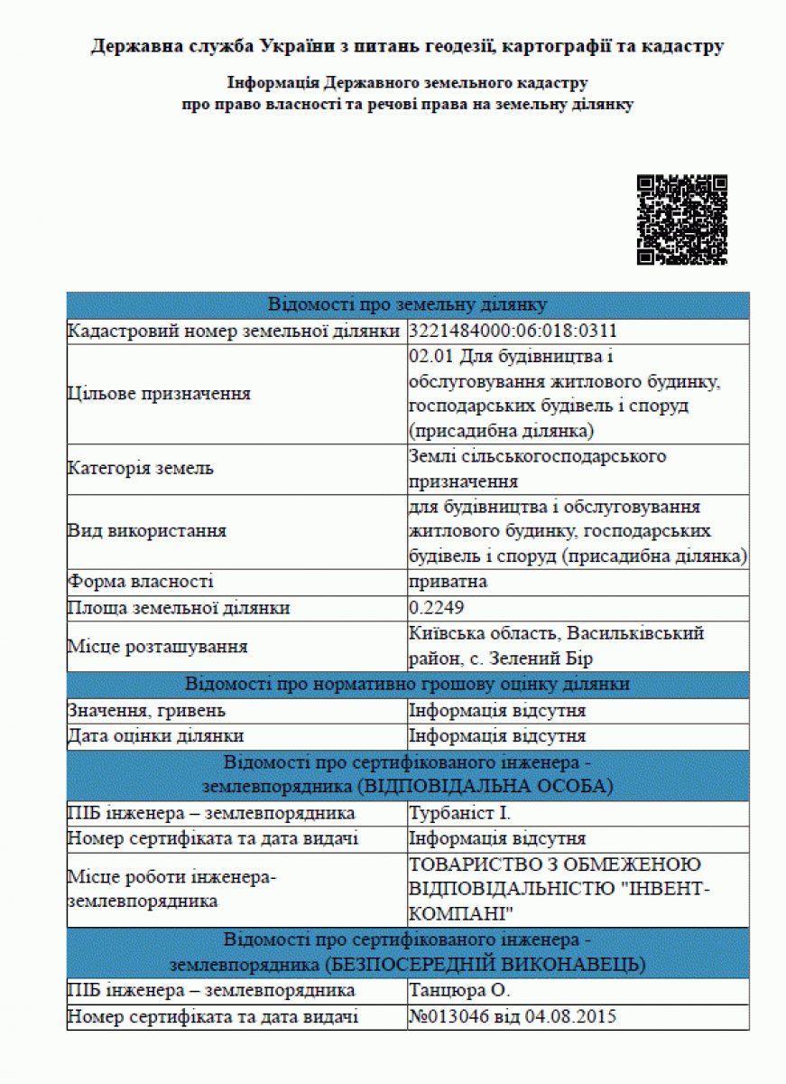
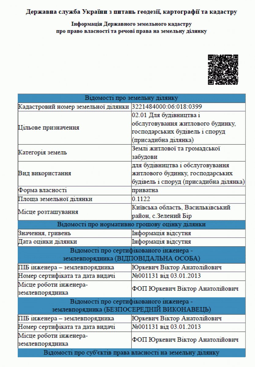
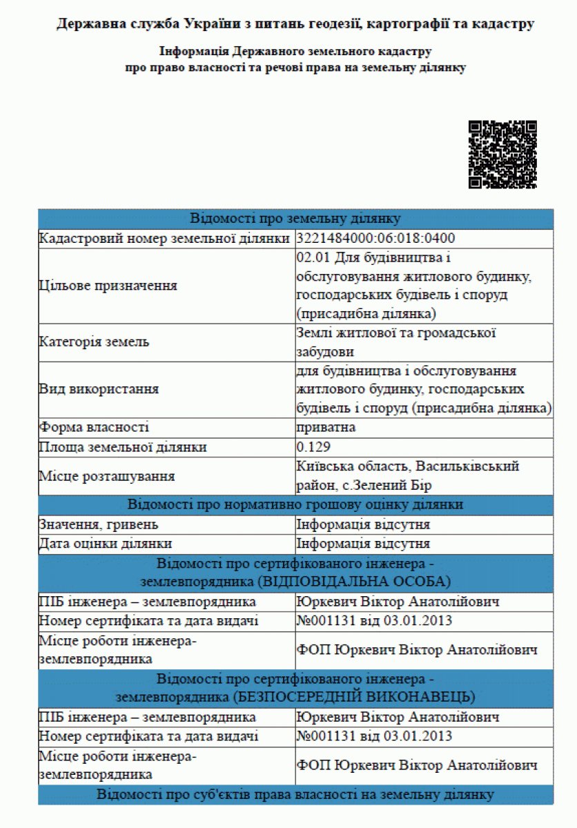
Formation of the GREENBOR land plots
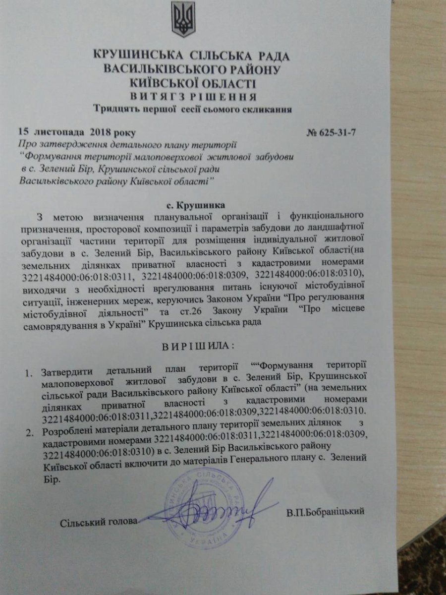
The present-day Phase 1 and Phase 2 of GREENBOR were formed within the Detailed Plan of the Territory approved by Decision No. 625-31-7 of 15 November 2018 of the Krushynka Village Council. The original planning area included land plots 3221484000:06:018:0309, 3221484000:06:018:0310 and 3221484000:06:018:0311.
The original plot 3221484000:06:018:0310 had the exact area of 0.2409 ha. It was divided into plot 3221484000:06:018:0399 with an area of 0.1127 ha and plot 3221484000:06:018:0400 with an area of 0.1282 ha; their combined area is 0.2409 ha.
Following subsequent cadastral actions — division, consolidation and formation of new land plots — the present-day set of plots 3221484000:06:018:0589–0608 was formed from part of the Detailed Plan area. It includes, in particular, the Phase 1 plots 3221484000:06:018:0594–0597 and the internal access-road plot 3221484000:06:018:0598.
For this reason, cadastral numbers that appear in earlier documents may differ from the current number of a particular household. The current cadastral number and area are shown on the relevant property page.
Separate land plots for each household
The GREENBOR project provides for 20 separate households — townhouses, duplexes and triplex units.
Each household corresponds to a separate land plot with its own cadastral number. This allows the buyer to acquire a specific house together with a defined private land plot rather than a share in common land.
Each property card in the sales section states:
- address / internal project reference;
- house type;
- house area;
- land-plot area;
- cadastral number;
- stage of readiness;
- equipment / fit-out;
- current price and purchase terms.
View GREENBOR homes and land plots
Internal road and common area
A separate land plot with cadastral number 3221484000:06:018:0598 and an area of 0.0937 ha has been formed for the internal road.
Including residential development, the road and additional land for infrastructure, the total area of GREENBOR is approximately 0.53 hectares.
The following are located or provided for in the common area:
- internal road and passages;
- gates and pedestrian gates;
- wells and technical premises;
- water-supply and on-site wastewater-management networks;
- electrical networks and lighting;
- video surveillance;
- waste-collection area;
- future recreation and landscaping areas.
ОК «Грінбор» is the registered legal owner of the existing shared infrastructure of the community. The internal road, common areas and existing infrastructure legally belong to the cooperative as indivisible property. Future infrastructure assets will be transferred to the cooperative after completion and legal registration.
Detailed Plan of the Territory
A Detailed Plan of the Territory for low-rise residential development in the village of Zelenyi Bir has been prepared for GREENBOR.
The Detailed Plan defines the overall planning organization of the territory:
- character of residential development;
- location of houses;
- internal driveways and passages;
- engineering networks;
- technical objects;
- landscaping elements.
The Detailed Plan of the Territory was approved by Decision No. 625-31-7 of 15 November 2018 of the Krushynka Village Council.
The Detailed Plan materials reflect the original construction concept. After the division of the land massifs, new cadastral numbers were assigned to the individual plots; therefore the numbers that appear in historical documents may differ from the current numbers of specific homes.
View the current community master plan
Engineering surveys of the site
Before the main construction works began, the surveys required for the design of the buildings, road and engineering infrastructure of GREENBOR were completed.
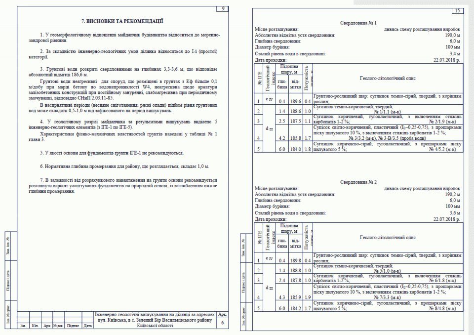
Engineering-geological surveys
The geological materials contain information on the composition and properties of the soils, groundwater levels and the engineering-geological conditions of the site.
These data are used by designers when selecting structural solutions and designing foundations. The foundation construction of a particular house is stated in its technical description.
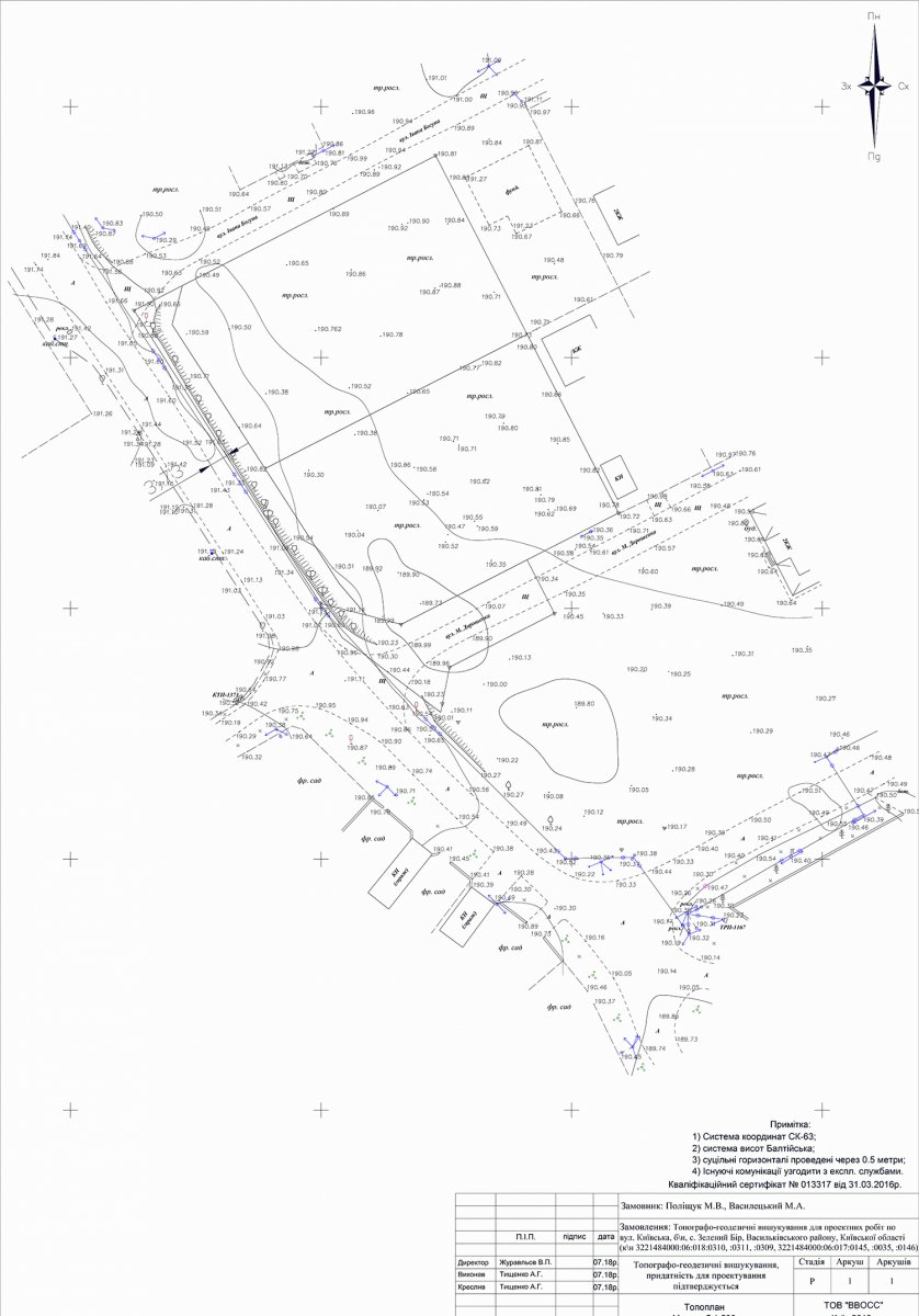
Topographic and geodetic surveys
The topographic materials show the relief of the territory, elevation marks, plot boundaries, existing objects and engineering networks.
They formed the basis for the placement of the buildings, the internal road, the passages and the shared infrastructure of GREENBOR.
Vertical planning
The vertical-planning scheme determines the organization of the terrain, the height location of buildings and roads, and the direction of surface-water drainage.
Each house also has its own system for the drainage of rainwater and meltwater, separate from the domestic wastewater system.
Documents of a specific house
The general GREENBOR materials confirm the preparation and planning of the territory. Separately, a set of documents for each specific house and land plot is prepared.
It may include:
- documents for the land plot;
- extract from the State Land Cadastre;
- cadastral number and plot area;
- project materials of the house;
- technical passport;
- document confirming that the house has been commissioned (declared ready for operation);
- documents concerning the official postal address, if issued;
- information on the state registration of ownership title.
For completed properties the buyer can review the documents before the purchase is completed. The current status of the documentation is also indicated on the relevant property card.
What you can check before buying
When selecting a specific property you can:
- match the house address / internal project reference with the community master plan;
- verify the area and cadastral number of the land plot;
- review the technical passport of a completed house;
- check the commissioning document;
- clarify the status of state registration of title;
- compare the documents with the actual condition of the house;
- ask questions about the content of the documents during a viewing.
The documents of a specific property are checked in their current state as of the date of the transaction.
Select a GREENBOR home · Request a viewing and review of documents
FAQ
Why do early documents and property cards show different cadastral numbers?
Early documents reflect the original land massifs. After their division, separate land plots were formed for the households, the internal road and the infrastructure, and these plots were assigned new cadastral numbers.
Does each household have its own private land plot?
Yes. Each GREENBOR household corresponds to a separate land plot with its own cadastral number. The area and the related documents are shown on the property card.
What does the Detailed Plan of the Territory confirm?
The Detailed Plan defines the planning organization of the territory, the character of the development, the location of roads, engineering networks and other objects provided for by the project.
Is the Detailed Plan a document for a specific house?
No. The Detailed Plan concerns the planning of the entire territory. Each specific building has its own project, technical and registration documents.
Can I review the documents of a particular house before buying?
Yes. The buyer can receive the documents of the selected house and land plot for review before the purchase.
Where can I see the cadastral number and area of a specific plot?
This information is placed on the corresponding property card in the sales section.